Subscribe to our Telegram channel for our latest stories and breaking news.
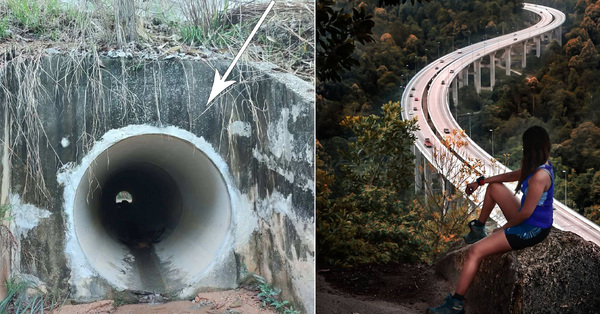
In the mood for an adventure? There’s a hike in KL that will bring you to top of a hill with a beautiful view of vast greenery surrounding Malaysia’s tallest highway.
Image via @rdkhril (Instagram)
Image via @88milestones (Instagram)
Image via @mikimeikee (Instagram)
Located about a 45-minute drive from KL city centre, the Bukit Kuari or Rawang Bypass trail will take you through dirt roads, tunnels, and along highway walls with ropes, until you reach a 233m viewpoint
Image via @anne_osman (Instagram)/dahcuti
Several hikers mentioned that you might spot birds inside one of the tunnels but don’t be alarmed, and just keep walking.
Image via @michelleee_leong (Instagram)
Image via @shawnloong (TikTok)
At the peak, also known as ‘Bukit Matt’, you’ll be able to enjoy a panoramic view of the Rawang Bypass, which took 12 years to construct, earning its title as the tallest highway in Malaysia.
Whether you choose to hike in the morning or evening, the viewpoint serves stunning backdrops
Image via @bryan9_7/@aimeesolo (Instagram)
Image via @benjyguan (Instagram)
Image via @kee_budakmerah (Instagram)
Image via @chuaweikiat (Instagram)
There’s also another trail you can take that leads you underneath the bridge, where hikers often frequent to snap photos as well.
Image via @farouq.johari (Instagram)
Image via @sj061190 (Instagram)
Check out this TikTok by @shawnloong who hiked there earlier this year:
What a view
If you plan to head there, please make sure that you’re fully vaccinated and are aware of the weather conditions, as you may need to walk through tunnels
If it rains, it can be extremely dangerous, so hikers strongly advise against it, as it can get flooded and become slippery. Basically, just be careful and don’t get the place banned!
You can find plenty of detailed directions online, including here.


